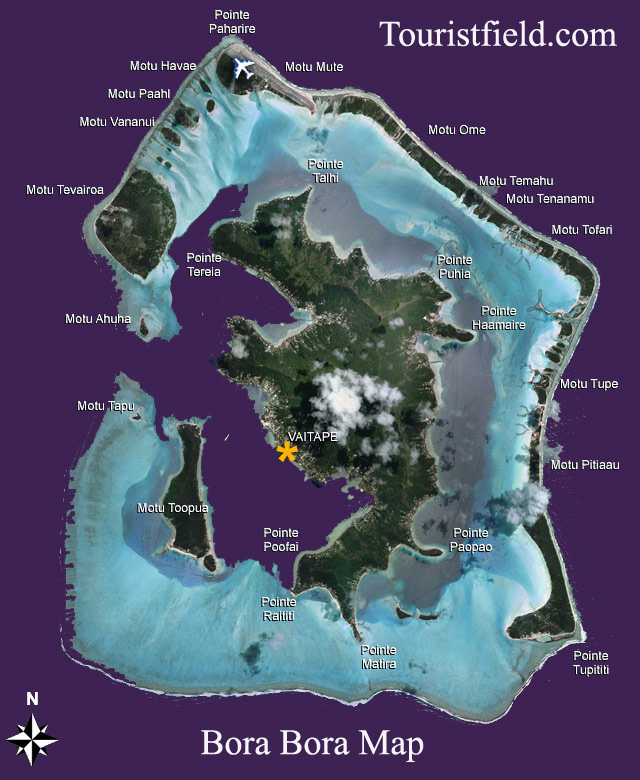
Bora Bora map location is located in the South Pacific Ocean, specifically in French Polynesia. This tropical paradise is situated approximately 230 kilometers (143 miles) northwest of Tahiti, the largest island in French Polynesia. Bora Bora is renowned for its stunning landscapes, crystal-clear turquoise waters, and overwater bungalows that attract tourists from around the world. To provide a detailed exploration of the island’s map location, we’ll delve into its geographical coordinates, surrounding geography, and key points of interest.

Geographical Coordinates: Bora Bora map location is positioned at approximately 16.5000° S latitude and 151.7500° W longitude. These coordinates place the island in the heart of the South Pacific, making it part of the Society Islands archipelago. The region is characterized by its remote location, surrounded by vast stretches of ocean.
Surrounding Geography: The island of Bora Bora is encircled by a lagoon and barrier reef, creating a distinctive landscape that has become synonymous with tropical paradise. The lagoon’s shallow, turquoise waters contrast with the deeper blue hues of the surrounding Pacific Ocean. Mount Otemanu, an extinct volcano, dominates the island’s center, adding to its dramatic and picturesque topography.
The main settlement on the island is Vaitape, located on the western side. Visitors typically arrive at the Bora Bora Airport, situated on Motu Mute, a small islet in the lagoon. From there, boat transfers or short flights connect travelers to the various accommodations and attractions spread across the main island and its surrounding motus (islets).
Key Points of Interest:
- Matira Beach: Located on the southern tip of the main island, Matira Beach is renowned for its powdery white sand and clear, shallow waters. It is a popular spot for swimming, sunbathing, and enjoying breathtaking sunsets.
- Mount Otemanu: Rising 727 meters (2,385 feet) above sea level, Mount Otemanu is the highest point on Bora Bora. Though hiking to the summit is a challenging endeavor, it offers panoramic views of the island and its surroundings.
- Coral Gardens: Bora Bora’s lagoon is home to vibrant coral gardens teeming with marine life. Snorkeling and diving enthusiasts can explore these underwater wonders, encountering colorful coral formations and a variety of tropical fish.
- Vaitape: The main village of Bora Bora, Vaitape, offers a glimpse into the local way of life. Visitors can explore the market, shops, and sample Tahitian cuisine at the island’s restaurants.
- Matira Point: This scenic overlook provides stunning views of Matira Beach and the lagoon. It’s an ideal spot for photography and taking in the beauty of Bora Bora.
- Motu Tapu: This private islet is often used for exclusive events and is known for its pristine beaches and clear waters. It is a popular destination for romantic outings and private excursions.
- Bora Bora Lagoonarium: A unique attraction where visitors can swim with and observe various marine species in a natural environment. It offers an educational and interactive experience for those interested in marine life.
In conclusion, Bora Bora’s map location showcases a remote island paradise set against the backdrop of the vast South Pacific. Its geographical coordinates, surrounded by a stunning lagoon and barrier reef, contribute to the allure of this tropical destination. The key points of interest, from iconic beaches to scenic viewpoints and cultural hubs, make Bora Bora a sought-after destination for travelers seeking a luxurious and idyllic escape.


